Copper Canyon 500mile Hike #5 / コッパーキャニオン500マイルハイク#5
写真/文:ジャスティン・リクター 訳:大島竜也/三田正明
5回に渡ってお送りしてきたトラウマのコッパー・キャニオン・ハイキング・レポートも、遂に今回で最終回を迎えます。この旅の最後の峡谷、シンフォローザに達したトラウマとカムは、メキシコ麻薬カルテルの大麻薬栽培地帯に足を踏み入れていきます。 500マイルを歩いて、旅の最後にトラウマが感じたこととは…。
■Day 26:道端に落ちた大量のマリファナ
朝起きると霜が下りていた。その日は凍える出発となり、僕たちは手持ちの服をすべて着込んで歩き始めたけれど、30分も経たないうちに地平線の上に太陽が昇り始め、すぐにいつもの短パンとTシャツ姿に戻った。朝食時、僕たちの“Hiker Hungly”を満たすには完璧なタイミングで村にたどり着いた。小さな店を見つけ、女主人に何か作ってくれるよう頼むと、コーヒーとコーラと卵と豆、そしてできたてのトルティーヤからなる素晴らしい朝食にありつくことができた。彼女はこの地域のドラッグ産業の恐ろしい話や、この近くの台地に土地を買って移り住んできたアメリカ人夫婦の話をしてくれた。ニュー・メキシコから来たその夫婦は定年後にここにやって来て、今は農業を営んでいるという。 すっかり満腹になった僕たちはふたたび歩きだしたが、その日はそれから大した出来事は何もなかった。まずはお馴染みの未舗装路と、その後はこの旅で僕たちが体験した唯一の長く続く舗装路を歩き続けた。午後、急カーブを曲がると大量のマリファナが道端に落ちていた。末端価格が少なくとも数千ドルにはなるだろう収穫された作物が、無造作に道の脇に転がっていたのだ。おそらくピックアップ・トラックの荷台に積まれていたものが、急カーブを曲がる際に落ちてしまったのだろう。僕たちは素早く写真を何枚か撮り、誰かが取りに戻る前に立ち去ることにした。この3週間、ドラッグに関するサインはいくつも目にしていたが、僕たちはついにその心臓部に足を踏み入れたようだった。
Marijuana on the side of the road.(道の傍においてあったマリファナ)
その日は未舗装路の脇に建つ高い石垣の陰で目を覚ました。僕たちは蜘蛛の巣のように広がる未舗装路を、支流沿いの小屋を目指して20kmほど下った。小屋でカウボーイ・ハットを被った白内障の老人に話を聴くと、僕たちの向かう最後の峡谷へ流れ込むシンフォロ―ザ川に下るトレイルは、ここ最近ドラッグの運搬路として使われているため、普通の人はめったに通らないという。彼は数年前に強盗に襲われ、家に侵入されて銃を突きつけられたこともあると話し、地元の人は横行するドラッグ・ビジネスに嫌気が差しており、また安全に暮らせることを願っているという。老人は軒先のリンゴの木からいくつか実を採り、持たしてくれた。僕たちは老人に礼をいって別れを告げ、ふたたびトレイルを下っていった。 その何分かのち、このトレイルは支流沿いに伸びるメインのトレイルに繋がっているらしいことがわかってきた。30分ほど経ったころ、十代の若者がスクール・バッグを背に嵐のように走ってきて反対方向に走り去っていったが、僕らの存在にはまったく気付いていないようだった。明らかに彼はマリファナの運び屋だった。僕とカムをお互い顔を見合わせたが、このまま進むことにした。 さらに30分ほど進むと分かれ道があり、状態の良いトレイルと悪いトレイルに別れていた。状態の良いトレイルはふたたび峡谷のへりに続く登り坂で、もう一方は僕たちの目指す方向に続いているようだった。状態の良いトレイルを歩きたいのはやまやまだったが、そちらは明らかに僕たちの目指す方向とは違っていた。ドラッグの運搬に使われるトレイルほどよく整備されているものなので、僕たちの希望はこの状態の悪いトレイルがすこしは安全であるということだけだった。
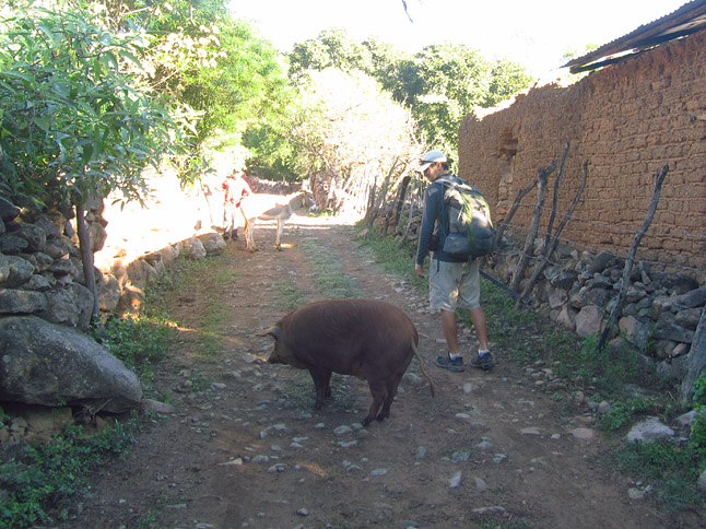
Walking through a small town.(小さな町を歩いて通る)
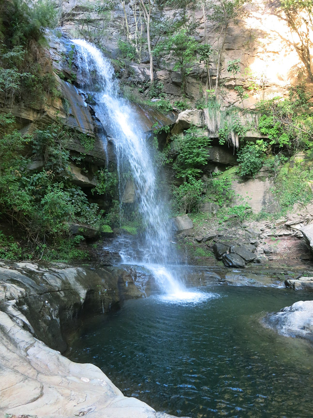
The waterfall and camping spot we came across at the perfect time. (タイミング良く見つかった滝が付近にあるキャンプ場所)
翌朝、さらに3時間ほど岩から岩へと飛び移ったり這い降りたりして、遂に僕たちは峡谷中心部の底へと辿り着いた。途中、またいくつかのケシやマリファナの栽培地を通過し、何人かの農夫と会ったが、昨日会った農夫のように親切な人はいなかった。「出荷」のため、彼らが峡谷のへりまでのこのハードなハイキングを日常的にやっているとは、まったく想像を絶した。鍛え抜かれた僕たちでさえ峡谷の底までほとんど丸一日かかったのだ。ここを登るのにどれだけ時間がかかるかは想像できたけれど、それがどれだけの稼ぎになるかは想像もつかなかった。だが、どれだけ時間がかかろうとも、それは彼らにとってやらなければならないことなのだろう。 僕たちは岩と岩の間を飛び越えて川を渉りながら、峡谷の上流へと進んだ。 いくつかの徒渉は腰や胸の高さまで水深があったものの、川はこれまでよりもずっと浅くなり流れも穏やかだった。僕たちは素晴らしい時間を過ごし、川沿いにロバ用の家畜道を見つけた。 昼前には昨日よりももっと大きなドラッグを栽培する農場を通り過ぎた。そこは全長2km以上もあり、スプリンクラーがくまなく設置されていた。肥料用に撒かれた卵の殻の上を歩きながら、僕は農家に心の中で感謝した。少なくとも、この場所ではまずまずのトレイルの上を歩けるのだから。僕たちは峡谷の底を旅するとはどういうことなのか、まったくわかっていなかった。峡谷の底にある岩や堆積物の大きさや徒渉の数によって、旅は素晴らしくもなるし、時に這いずりまわる羽目にもなる。この時はずっとなだらかな道が続いたので、素晴らしい時間を過ごすことができた。
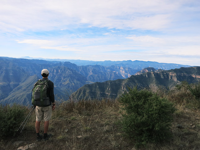
At the rim at the Cumbres de Sinforosa, the end of the journey.
(僕らの旅の終着点、カンブレスデシンフォロサの縁にて)
■Day 29: バスでたった4時間の道
もしすべてが予定通りにいけば、今日が最終日になるはずだ。道の状態さえ良ければ、半日もあれば津着するだろう。あとはただ、峡谷のへりまで登りきればいいのだ。その日、行く先に日陰がまったくないことがわかっていたので、あの拷問のような太陽の光を避けるためにかなり早く起床した。僕たちはこの旅でも最高のクオリティーのロバ道(正確なつづら折りと歩きやすい階段!)で1800mの標高差を4時間で登りきり、午前10時半には峡谷のへりに到達することができた。 赤い壁をしたシンフォローザ峡谷の景色は素晴らしく、“Cumbres de Sinforosa”(シンフォローザ峡谷の最高峰)の姿はこの旅を締めくくるに相応しい眺めだった。歓びもつかの間、次なる課題が僕たちを待っていた。ここからグアチョーチの町までは30kmほど離れており、その後にクリールの町に僕たちのダッフルバッグをピックアップして、そこから一番近い空港のあるチワワまで行かなくてはならない。運良く町へと向かうピックアップトラックに乗せてもらうまで、僕たちはそれから12kmほど歩き続けた。 ようやく町に着き、僕たちは腹一杯食べ、このハイキングをやりきった達成感に浸った。当初はどんなことが起こるのか、巨大なクエスチョン・マークだらけだったこの旅を、ドラッグ栽培地帯をくぐり抜け、どうにかシンフォローザまで辿り着くことができたのだ。僕たちがクリール行きのバスに乗り込むと同時に雨が降り出した。歩いて3週間かかった道は、バスではたったの4時間だった。
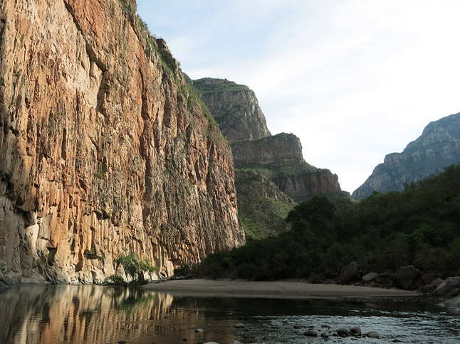
The Sinforosa River and canyon.
(シンフォロサ川とキャニオン)
今回の旅は、グランド・キャニオンよりも深いことで知られる驚くべき魅力を持つ地域、コッパー・キャニオン全域を横断するものだった。このふたつの地域は非常にドラマチックで起伏に飛んだ地形をしており、コッパー・キャニオンには多くの美しい場所がある。だが、全体的な景観美はグランド・キャニオンの方が優れていると僕は思う。 グランド・キャニオンで、僕は今まで訪れたどの場所でも「ぶっ飛ばされた」。だがコッパー・キャニオンでは、いつもそうとは限らなかった。峡谷において、すべてを洗い流す鉄砲水は大地の浄化であると僕は思っている。メキシコではゴミをゴミ置き場に捨てる習慣が徹底されていないため多くのゴミが峡谷に流れ着き、植生を妨げている。このため人里から遠く離れた場所でも、手つかずの自然を感じることができないのだ。 また、メキシコでは経済の拡大と共に、以前はハイキングやロバ道でしか交通がなかった村々に道が通されようとしている。それら多くの道は新し過ぎて僕たちの地図には載っていなかった。こういった道路建設用の資金は麻薬カルテルが彼らの「製品」をより容易に運搬する目的で工面されている可能性がある。このことは、僕たちの様なハイカーにとっては地図と実際の道が異なる程度の問題で済むが、コッパーキャニオン地域の文化や伝統にとっては、さらに深刻な影響を及ぼすことになる。 この地に住むタラウラマ族はランニングとハイキングの文化を持っているが、それは彼らの住む地域が人里離れ、必然的にランニングやハイキングをしていたことに由来する。しかし、新しい道路は生活を楽にし、物品へのアクセスをもたらすことになる。この変化は自然の流れであり、良いか悪いかは僕にはわからない。しかし生活が楽になるにつれ、古くから続く文化は失われてゆくだろう。この葛藤は僕たちが自然界から遠ざかれば遠ざかるほど起こる問題だ。何世代にも渡って使われてきたトレイルにも草木が生茂り、朽ち果て、使われなくなっていく。
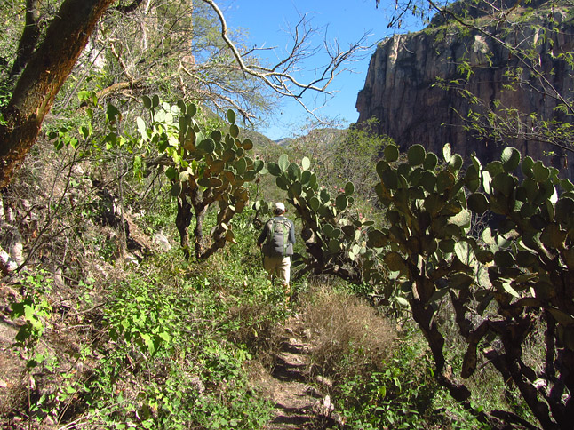
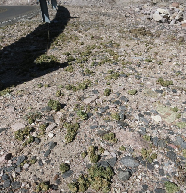
Walking on an old Tarahumara trail through the desert vegetation. (砂漠地帯に通る古くからあるタラウラマ族が使った道を歩く)
Copper Canyon 500 mile Hike #5 by Justin Lichter
Day 26:
The plateau was lined with frost as we packed up and started moving. It was a chilly start to the day. We both had all of our available clothes on. Within thirty minutes, as the sun rose over the horizon, we were shedding layers and were back to shorts and our base layer shirts. We hit a small village around breakfast time, perfect time so that we could fuel our hiker hungry. We stopped at a small shop and asked the shopkeeper if she would cook us breakfast. We had coffee, Coke, eggs, beans, and fresh tortillas, as the lady told us stories about the area and the drug trade. Besides for the horror stories about the drug industry, she told us that a couple from the United States had purchased a place on the adjacent mesa (as she pointed across the canyon). The couple, originally from New Mexico, had retired to this area and bought a plot of land. They now lived there full time and farming. We left with full bellies and headed out down the dirt road. The rest of the day was pretty uneventful as we connected the dirt road with one of the only paved road walking stretches that we had on the entire trip. In the afternoon, along the 15km paved road stretch, we were walking around a sharp bend in the road, when we noticed loads of marijuana splayed out along the side of the road. There was easily thousands of dollars of harvested crop just lying next to the road. I took a couple of quick pictures and we pressed on before anybody returned to pick up their loss. We presumed that a pick up truck was going fast around the corners of the road and lost some of the contents from the bed of the truck. After three weeks of relatively little signs of drugs, we knew we were now in the heart of it.
Day 27:
We woke up from behind the shoulder high stonewall providing cover from the nearby dirt road. We made our way about 20 km more down a spider web of dirt roads and to a house situated on the rim of a tributary. We spoke to the owner of the house, an older man with bad cataracts and a cowboy hat. He said that there was a trail down the tributary that led to the Sinforosa River, our final canyon. He also mentioned that he hadn’t seen anyone use the trail in a few years, except for people he presumed to be growing and carrying drugs. He told us the story of how a couple of years ago, he was held up and robbed at gunpoint in his home from some of the drug people. The locals all were fed up with the drug industry and would like to feel safe again. He picked a few apples from his apple tree and gave them to us as we said our good-byes and hiked off down a faint trail. Within a few minutes the trail improved as we hit the main trail in the tributary. Thirty minutes later a teenager with a school-style book bag stormed past us in the opposite direction without acknowledging our presence. He was obviously a “mule” packing out some of the drugs that were being harvested. Cam and I looked at each other and decided to keep going. Another thirty minutes later we came to a junction. The good trail ascended and appeared to regain the rim, while a faint trail continued in the direction we wanted down the tributary. It was hard to leave the good trail, but we knew it wasn’t headed in the right direction. The only hope was that all of the drug traffickers had built the good trail for their use and we were now safe on the lesser-used trail. We dropped elevation fast and the trail picked its way through cliff bands. The tributary gorged up and became steep with waterfalls. On the faint trail we traversed out along a ledge and then found our way steeply back down. The trail was more like a goat track. It was hard and nearly impossible to follow, until suddenly it emerged at a tilled field on a 45-degree slope. Sprinklers were firing overheard watering the recently sewn seeds. We made our way across the field hollering “Hola, Buenos dias” so that we wouldn’t startle anybody. On the other side we had trouble finding the goat trail. We continued down a faint trail and then came across another tilled area. I saw some flowers and quickly realized that we were in a poppy farm. This was getting serious. They were growing poppies to make heroine, not just marijuana. We kept going as we shouted “Hola, Buenos dias” like a broken record. As we stumbled on the next field we saw a fire smoldering in an alcove above the field. Then we saw the farmer. We shouted out to get his attention. He came over and chatted cordially with us. He was very friendly and asked all about what we were doing. We were cautious with out answers and told him we were hiking and wanted to get down to the main river and then hike up the Sinforosa to Guachochi. He said that we had gone the wrong way and lost the trail that dropped through the last rock band since we had ended up in his fields. Finally he said that there was another way to get to his friend’s field down along the river. Good news that we could make it down to the river, but bad news that there would be more fields to pass through. He pointed the direction down this steep nose and then told us to look for a trail that wrapped left around this cliff band into the next tributary and then dropped to the confluence. We thanked him and went on our way before anything could go awry, after all we were talking with a poppy farmer. Within five minutes we were completely lost and bushwhacking down a 45-degree hillside with loose soil and scrambling for our lives as we tried to find a way to the river bottom. Cam slipped and almost uncontrollably went over the cliff band below. We grabbed plants to maintain some balance. After 40 minutes we decided to turn around and go back up, but we were hesitant to go back to the farmer for more directions. As we regained the nose protruding from the ridge, we noticed a very faint trail wrapping around as he had mentioned. The sun was now setting and the daylight was fading fast. We hoped this was right and we would be able to find a flat spot to camp. The last thing we wanted was to retreat to the farmer’s alcove and be forced to camp with someone in the drug industry. Anything could have happened then. We bushwhacked and followed the faint trail around. As it wrapped around it skirted cliff bands and precarious ledges. It emerged at the side stream at an idyllic spot. A waterfall poured into a large pool and just above the first flat ground we had seen in hours. We knew it was our home for the night. It was a perfect spot in any other setting. Our only fear was the thundering water would cover noise of anybody approaching.
Day 28:
It took us another three hours of scrambling and rock hopping to finally hit the main canyon bottom. We passed through a few more drug fields and met a couple more farmers, none as friendly as the one the previous day. It was unimaginable that people would routinely make this hike to transport their drugs up to the rim for “shipment”. We were in amazing shape and it took us almost a full day to descend to the bottom. I can only imagine how long it takes them to ascend on that route. I can’t imagine that is a profitable endeavor, with how much time it takes, but it must be. We made our way up the canyon, rock hopping and fording the river. The water levels were lower and manageable since we were farther up canyon and past a main tributary. Some of the fords were still waist or chest high though. We made good time and found some donkey trail on a few flat benches above the river. Around the middle of the day we passed through another large drug field. This one was over 2 km long and sprinklers were on throughout. We walked on eggshells as we traversed the field, secretly thanking the people because at least there was a decent trail in places. We never knew how the travel on the canyon bottoms would be. Depending on the size of the debris and rubble and number of fords necessary, sometimes we’d make good time and other times we’d be crawling. This was a particularly long stretch in the bottom but we were making great time. Around lunchtime we realized that by the end of the day we might make it to the junction where the trail was for us to ascend out of the canyon for the end of the hike. The going remained good. We reached the area we presumed was the junction an hour before dark. We scouted around a little and found the trail that would take us 6000 vertical feet up to the rim. We decided to get water and relax and absorb the remaining hours of the hike in the remote canyon bottom.
Day 29:
If all went as planned, we knew this was the final day, maybe even just a half day of hiking if the trail quality was good. All we had to do was follow the trail to the rim. We woke early to beat the heat since we knew the climb had no shade and would be grueling in the sun. We ascended quickly on the highest quality donkey trail of the entire trip. There were great switchbacks and well graded tread. We reached the rim of the canyon at about 10:30 in the morning after less than four hours of hiking and 6000 feet of elevation gain. The view was amazing looking out over the Sinforosa Canyon and its red walls. The Cumbres de Sinforosa (Summit of Sinforosa) was a great ending point. Now we turned to the next task at hand. Getting to the town of Guachochi, about 30 km away, and back to Creel to get our duffel bags so we could head to Chihuahua and the nearest airport. We had to keep walking since we were at the end of a little used dirt road that only led to this viewpoint. We walked at least another 12 km before we got a ride in the back of a pick up truck into town to. We ate a hearty meal, satisfied that we completed the hike, where everything at times was a huge question mark about what we would face, and made it out of the Sinforosa and the throat of the drug cultivation. Then we caught the bus back to Creel as it started raining. What took us three weeks to hike, took us only four hours by bus. Conclusion: This trip was through an amazing region traversing the entire Copper Canyon. The Copper Canyon is known as being deeper than the Grand Canyon in the United States. The terrain in both is dramatic with huge relief changes. Many areas of the Copper Canyon were stunning, however when compared to the Grand Canyon, I think the Grand Canyon is overall more aesthetic. From anywhere I have ever been in the Grand Canyon, I am blown away. This was not always the case for me in the Copper Canyon. I tend to think of flash floods in the canyon systems as the Earth’s cleansing. Everything gets washed and flushed through the canyon. In Mexico, where there is less of a tendency to dispose of garbage into a receptacle, this in turn means that a lot of trash gets flushed into the canyons and hung up on vegetation. It doesn’t always have a pristine feel, even though you might be in a really remote location. Along those some lines, Mexico, as an expanding economy, is trying to put roads into many areas that were previously only villages serviced by hiking and donkey trails. Our maps did not show a lot of roads that were built. This could also be due to the money from the drug trade and the cartels wanting it easier to transport their products. This affected our hike as we went, since our maps were not current, but most importantly this has affected the culture and traditions of the Copper Canyon region. The Tarahumara were a running and hiking culture. With new roads people gravitate towards the roads since they can make life easier and create access to goods. This naturally changes things, whether for good or bad, I am not sure, but ancient cultures are lost because life becomes easier. It’s conflicting. As this happens we naturally become more separated from the natural world. Trails that were built and used for generations are becoming overgrown, decaying, and becoming unusable. Ultimately we had gone into this trip with the intention of showing that the media, as is typically the case, was scaring tourists from coming to this amazing area. We intended to write a guidebook for the hike and for other hikes in the area, as well as possibly guiding hiking trips into this remote region. After a week on the hike, we learned that these ideas wouldn’t be possible. The drug trade has infiltrated the area more than we realized. We felt safe at most times, but would not want to be responsible for other people. Even the majority of the local people are not happy about this. Most have lost a lot of opportunity because of the decrease in tourism over the past ten years. What was once a worldwide destination and thriving tourist mecca, sits empty with slews of hotels boarded and shuttered. We had hoped to invigorate this again to help the local people and bring money into the local communities, as well as to bring about ideas of conservation and national park creation. We hoped to promote eco-tourism and hiking in the area. We were too optimistic. The region is still in too much turmoil and is too risky. Many of the local people want to move past the drug culture and stigma, but others, like many of the friendly drug farmers that we met merely look at it as a job that pays them more than if they were growing corn or wheat. Not that they are growing a destructive and addictive drug, that usually ends up in the hands of youth in the United States, while also creating dangers and chaos in their homeland. It would be great if conservation could be implemented to protect the region from additional intrusion from roads and development. The area could easily be one big national park and would bring money to the local economy, maybe saving people from the temptations to grow drugs. The trails used by the Tarahumara for generations could easily be resurrected to create a prime hiking destination. The Copper Canyon could be that next scenic destination, when things turn the corner.
TAGS:


 ULギアを自作するための生地、プラパーツ、ジッパー…
  Tenkara USA | RHODO (ロード)
  Tenkara USA | YAMA (ヤマ)
  Tenkara USA | Rod Cases (…
  Tenkara USA | tenkara kit…
  Tenkara USA | Forceps & …
  Tenkara USA | The Keeper …
  Tenkara USA | 12 Tenkara …
  Tenkara USA | Tenkara Lev…