Copper Canyon 500mile Hike #4 / コッパーキャニオン500マイルハイク#4
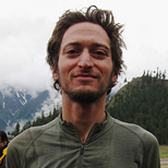
写真/文:ジャスティン・リクター 訳:大島竜也/三田正明
2013年の11月、トレイルランナーのバイブル『BORN TO RUN』 の舞台としても有名なメキシコのコッパーキャニオンへと500マイル(805km)のハイキングへと旅立ったジャスティン・リクターa.k.a.トラウマとカム。
道なき道を行き、増水した川を何度も渡り、たくさんの人々との出会いと別れを繰り返しながらいくつもの峡谷を越えてきたこの旅も、ついに終盤に差し掛かってきました。今回は『BORN TO RUN』にも登場するウリケやバトピラスの町をトラウマが訪ねます。
■DAY 14,15 & 16/ウリケの町
クリールの街で僕たちは今後のハイキングに備え休息日を取ることにした。そしてそれは家から持ってきたダッフルバッグからギアや食料を補給する最後の機会だった。その日は日曜日で、僕たちはテレビでスペイン語実況されるアメリカン•フットボールを観ながらギアの整理をし、ピザとアイスクリームとメキシコ料理の休日を満喫した。
月曜日の朝、僕たちの出発準備は完璧だったが、(数日前ヒッチハイクした)ディヴィサデロに戻るバスは昼前までやって来なかった。ようやくバスに乗り、数日前ピックアップトラックに拾ってもらった場所のあたりで下車し、峡谷のへりを歩き始めた。ウリケ・キャニオンを見ると川が増水していたので、峡谷のへりの上をウリケの町へ下るまでの70キロをそのまま進むことにした。
歩き始めは舗装されていた道路は徐々に荒れた未舗装路になっていった。午後は線路に沿って歩き、長いトンネルをいくつか越えた。トンネル内部の線路脇には隙間がほとんどなく、いまここを列車が猛スピードでやってきたらと思うとゾッとしたけれど、幸運にも列車はやって来なかった。
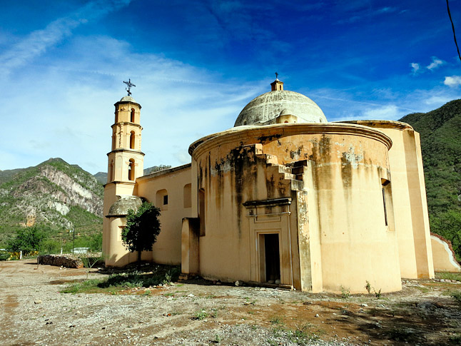
An old church along our route.(道の途中にあった古い教会)
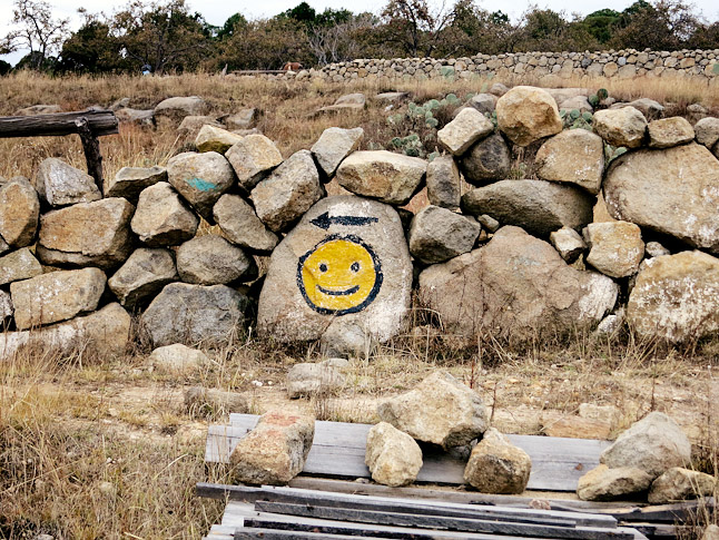
翌朝、僕たちはふたたび未舗装路を南に向かって数時間歩き、小さな村をいくつか通過した。そのひとつの村を通り抜けるとき、小さな商店の前でジーンズとカウボーイブーツ姿の男たちが話し込んでいるのを見かけたが、そのうち何人かはAKアサルトライフルを肩から下げていた。僕らは急いでそこから離れ、村はずれの道の行き止まりまで歩き続けた。
そこからポンデロサ松の森に尾根に沿って踏み入り、消えかけたけもの道を辿って歩いた。岩棚までやってきたとき、僕たちはそこが峡谷の底までの下りが始まる場所だと思っていたので、急斜面の道なき道を慎重に下っていった。けれど30分ほどで岩壁に囲まれた場所に出ると、そこより先へ下ることができなくなってしまった。登り返して周囲を見渡し、GPSの電源を入れ位置を確認すると、自分たちが思っていた場所とはまったく違う場所にいることがわかった。僕たちは完全に地図を読み間違えており、峡谷の底へ下るにはもう少し先まで進まくてならなかった。地図には載っていないが目的の方角には続いていそうな未舗装路を見つけ、数kmほどそこを行くうちに、僕たちは渓谷の底へと下るにはもっと峡谷を上へ登らなければいけないことに気がついた。けれどそこで道は終わり、気がつくと僕たちは断崖絶壁の上にいた。
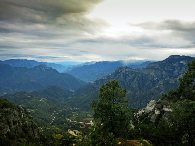
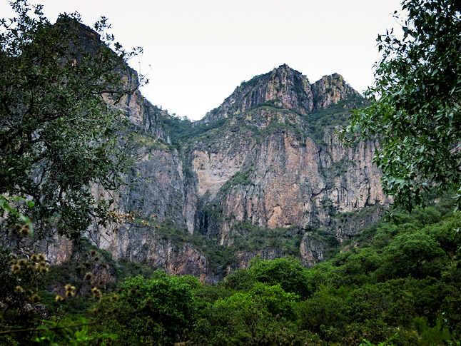
かすかについたけもの道を頼りに斜面を登って行った。トレイルは徐々に歩きやすくなり、過去に農場があったと思われる小さな平原に出た。あたりを見渡しトレイルの続きを探したけれど見つからず、平原を横切ると峡谷の底から1500mほど切り立った崖の上に出た。そこからは今日僕たちが行くべきルートが700~900mほど下に見え、その先には今夜の目的地である歴史あるウリケの町へと続く道も見えた。もっとも、町へは昼過ぎには着く計画だったのだけれど。
Looking down at the descent into Urique.(ウリケの町を見下ろす)
崖下へと続くトレイルがないかと探したけれど、あるはずもなかった。僕たちはトレイルを諦め、急峻な山肌を降りることにした。数百メートルほど行くと牛用の家畜道の上に丸太が倒れており、牛が逃げないよう誰かが置いたようだった。その道を左に進むと数km先にふたたび丸太があり、明らかに人間が意図的に置いたに違いないと思った。人の手が入ってる様子から、僕たちはこのまま行けば予定通りこの切り立った崖を下りきり、ディナーまでには町へ着けるのではと希望を持った。
さらに400mほど行くと道はさらに歩きやすくなり、明らかに下へ下へと続いていた。つづら折りの家畜道はこの崖を下ることのできるたったひとつのルートに刻まれており、この道が見つからなかったらここを滑落せずに下る方法はなかっただろう。延々と続く下り坂にゼリーのような足になりながら、日没まであと30分の時点でようやく町へと続く道までたどり着いた。が、ウリケの町でディナーにありつくにはさらに暗闇の中をハイクする必要があることは疑いようもなかった。
Looking back at the area that we were lucky enough to find a trail that brought us down through the cliffs. it was amazing that there was a way down through the cliffs!(幸運にも崖を通るトレイルを見つけて下まで辿り着き、崖を見返した時の様子。まさかこんな崖にトレイルがあるとは!)
2時間半のナイト・ハイクの後、ウリケ川の河岸に広がる歴史あるウリケの町へと滑り込んだ。通りはすでに暗かったけれどプラザ・レストランが開いているのを見つけ、訪ねるとディナーもホテルの部屋も提供できると言ってくれた。オーナーは驚くほどフレンドリーで親切で、食事も素晴らしかった。夕食後、座っていると60代後半のオーナー2人がいろいろな話をしてくれた。彼らは町と外界をつなぐ曲がりくねった道が出来るずっと前からこの町に住んでいるといい、ベストセラーになった書籍『BORN TO RUN』に登場する伝説的なトレイルランナー、カバーヨ・ブランコがこのレストランの常連だった話をしてくれた。それはとても楽しいディナーで、僕たちは翌日ウリケの町を散策することが待ちきれなかった。
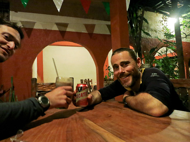
A toast in Urique at the Plaza Restaurant……chocolate milk (my favorite) and a beer for Cam. (ウリケのプラザレストランでチョコレートミルクとビールで乾杯!)
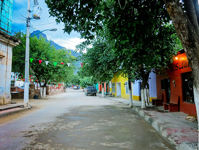
Downtown Urique(ウリケの町のダウンタウン)
翌朝、僕たちはさっそく支度をして町を歩いた。ウリケの町並みは魅力的で、道も清潔だった。官公庁前の広場にはカバーヨ・ブランコの小さな碑もあった。プラザ・レストランで朝食を食べ、町を出ようと歩き始めると、20分もしないうちに複数の男たちが近寄って来た。マリワナの売人だった。一人の男は歩きながらついてきて、袋からマリワナの房を出して無理矢理渡してこようとしたけれど、僕たちは丁寧にお断りをして足を進めた。
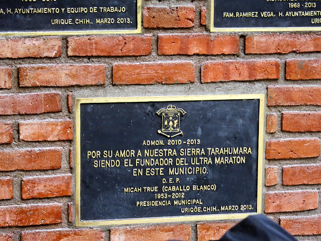
Caballo Blanco plaque in Urique. (ウリケにあるカバーヨ・ブランコの石碑)
■DAY 17 & 18/砂漠地帯の雨
ウリケとバトピラスというふたつの歴史的な街をたどる72キロの道は、コッパーキャニオンでも人気のハイキング・ルートだ。けれど1,500mの峠を越えてウリク川からバトピラス川へと行くその道はすでに輝きの一部を失っていた。ウリケの町を離れのどかな雰囲気に建つ一軒の小屋にたどり着くまでは、トレイルは素晴らしい状態だ。けれど小屋を過ぎるとトレイルは荒れ始め、明らかに歩く人が少なくなっていることが窺えた。
This way to happiness. (ハピネスはこちら)
僕たちは小屋の主人を訪ねることにした。プラザ・レストランのオーナーがトレイルのこの先の情報に関してはその小屋の主人に聞くのが良いと教えてくれたのだ。主人は庭でマンダリンを摘みながら話をしてくれた。庭にはバナナやグレープフルーツやアボカドや、その他たくさんの樹木が生い茂り、まるで彼だけの秘密の楽園のようだった。彼曰く、90年代以前は年に約3,000人のハイカーがここを通っていたが、最近では20人以下になってしまったとのこと。その理由は、この地域でドラッグの栽培や取引が横行しているため危険な場所だと思われているからだ彼は言っていた。政府からの補助金も人気トレイルだった頃の1/3程度になってしまったという。
主人に礼を言い、暗くなる前にその日の目的地に到着するべく足を進めた。翌日にはバトピラス川に向けて下り始めることが出来るよう、その日のうちに峡谷の上まで到着したかったのだ。そうすれば翌日の午後にはバトピラスの町に到着し、ゆっくりと町を探検することができるかもしれない。僕たちは標高差1,500mを登りきり、どうにか暗くなる前に峡谷の上まで到着したが、適当なキャンプサイトを見つけるのにとても苦労した。やっと平らとは言い難い松の葉で覆われた場所を見つけると霧雨が降り始めたので、僕たちはこの旅で初めてシェルターを使うことにした。
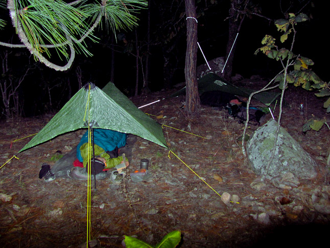
Camping in the rain in the Ponderosa forest on the rim. (ポンデロサの森にある山の縁で雨の中キャンプしている様子)
夕食後に雨はさらに激しくなったけれど、ここは砂漠地帯で雨期でもないし、僕たちはすぐにやむだろうを高をくくっていた。ところが雨は夜中激しく降り続けた。砂漠地帯の乾いた土は雨に流れやすく、テントのペグは刺してもすぐに浮いてきてしまった。雨のせいでよく眠れず、朝になっても動きたくなかった。いずれやむだろうと思い、テントを出る気にもなかなかならなかった。結局いつもより一時間遅く出発したけれど雨脚が弱まることはなく、一時間もしないうちに僕らはずぶ濡れになり、体も冷えきってしまった。
稜線上には強く風が吹き抜け、気温は3℃しかなかった。僕たちは今日の目的地である暖かな峡谷の底へ着くのが待ちきれなかったが、そこへと導いてくれるトレイルはなかなか見つからなかった。辺りは雲で覆われ、視界は悪く、地図は見るたびに水分を吸い込んでびしょ濡れになっていく。やがて小屋が見えてくると、中から子供が飛び出してきて「Hola!(こんにちは)」と言った。わざわざ乾いた家から雨の中へ飛び出してずぶ濡れになっている子供が、僕たちにはクレイジーとしか思えなかった。その子の両親も小屋のドアまで出て来てたので道を訪ねたけれど、言葉のギャップであまりよくわからなかった。僕らの体は雨で凍りつき、我慢ができず早く足を進めることにしたが、子供はずぶ濡れになりながらついてきた。僕たちにはその子にあげる物が何もないと説得すると、走って家に戻っていった。
その後、どうにか峡谷の下へと続くトレイルを見つけた。1時間後バトピラスまで残り19km地点の道の上に到着し、日没1時間前に町には到着できたが、最後まで雨はやまなかった。町を流れるバトピラス川は増水して茶色く濁り、雨の影響は町全体に及んでいた。どうにか屋根のある場所にたどり着き、ずぶ濡れになったギアを広げることができたが、快適なホテルの部屋とは裏腹に雨はその晩も降り続けた。
■DAY 19, 20 & 21/シンフォローザ・キャニオンへ
翌朝、目を覚ましてもギアや服は乾いておらず、豪雨の影響はまだ街のそこかしこに残っていたものの、少なくとも太陽は顔を覗かせていた。使い古された常套句だけれど、まさに「たった一日で世界は変わる(what a difference a day can make)」のだ。バトピラスの町の歴史的な建築物を見物し、食料を補給して情報を集め、町を出発した。道を進むと地図に載っていない未舗装路があり、それから数日間歩く予定だった道が新しく作られたその道に置き換わったことがわかった。僕たちは計画を変更して翌日翌々日と車通りがない道を進み、小さな村々を巡ることにした。峡谷の底から這い出て、少し大きめの町でレストランを見つけランチを食べた。
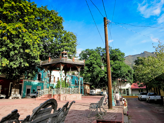
Downtown Batopilas after the rain cleared.(雨がやんだ後のパトピラスのダウンタウン)
すでにこの旅の最後の峡谷であるシンフォロ―ザ・キャニオンまですぐの場所まで来ていた。午後の間ずっと舗装路を歩いて24kmほど峡谷を下り、日が沈む頃に峡谷の底にたどり着いた。バトピラスの川はここ最近の大雨の後でまだ水嵩が高くとても徒渉は無理そうで、河を渡る良い案がないか考えながら僕たちは眠ることにした。
■DAY 22, 23, 24 & 25/ドラッグ農場
目を覚ますと、厚い霧が毛布のように峡谷の底を覆っていた。出発に向けてパッキングを始めると、霧のせいで寝袋にもたっぷりと露がついている。当初、僕たちはバトピラス川沿いに130kmほど進む予定だったけれど、川の水位を見る限りそれは得策とは思えず、舗装路を辿ってすこし離れた町へ行き情報収集をした上で、他の手段を探ってみることにした。
霧が晴れてきたころとてもフレンドリーな男性に会い、彼の家でコーヒーをご馳走されることになった。コーヒーを飲みながら辺りの様子について話を聞くと奥さんを紹介してくれ、彼女は僕らに手作りのタマレス(コーンの粉で出来たメキシコ版ちまき)をご馳走してくれた。更には彼の隣人も参加して色々と現地の情報を教えてくれた。僕らは彼らの助言に従ってバトピラス川の支流に沿ってふたたび峡谷の上に登り、洪水状態の川を迂回することにした。
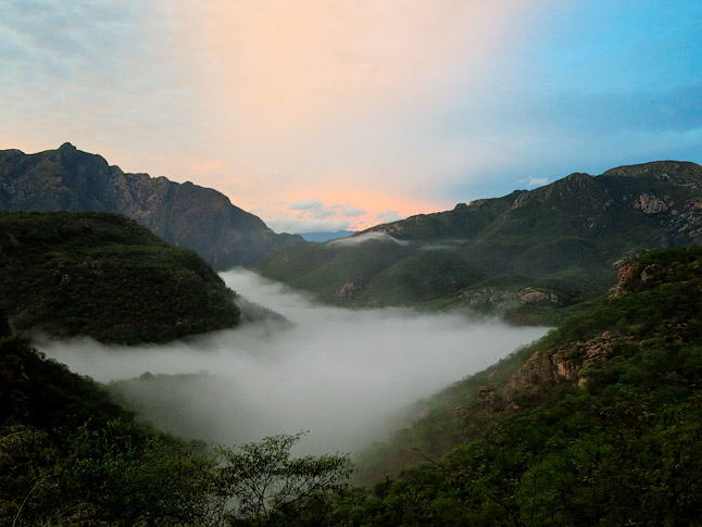
Sunrise and fog in the canyon. (峡谷に昇る朝日と霧)
しばしばトレイルは消えかけていたり入り組んでいたりして、そのたびに僕たちは分かれ道をどちらに行くか選ばなければならなかった。支流を進むと何かの栽培農場と小屋があり、十代の少年たちいた。話しかけてみるとまったく友好的でなく、その態度にここがドラッグの栽培農場であることは間違いなかった。急いでその場を離れ峡谷の上へと登っていくと、地図に載っていないのによく整備されたトレイルに出た。おそらくドラッグを運ぶために新しく作られたものだろう。
峡谷の上まで登り振り返ると、シンフォロ―ザ・キャニオンと川の支流の驚くべき眺めが見下ろせた。日暮れまで僕たちはさらに未舗装路を数km歩き、その夜はドラッグ関係者やギャングたちに見つからぬよう、道から見えない場所でキャンプをした。
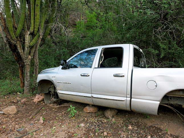
Expensive truck broken down and abandoned in the middle of nowhere, presumably from the drug trafficking in the area.(壊れてタイヤも取られた高級トラック。おそらく周辺のドラッグ取引で使われたのだろう)
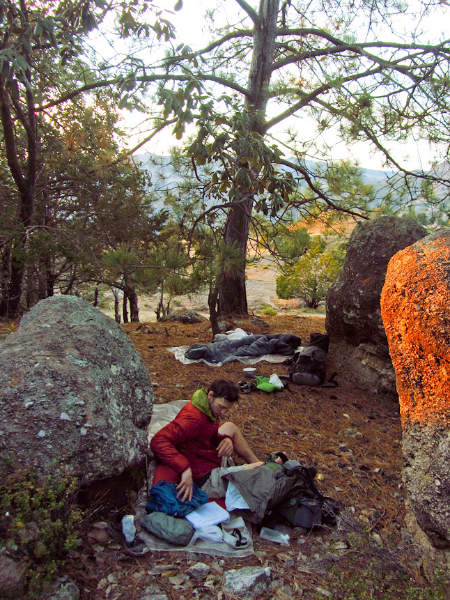
A hidden campsite along the dirt road walk. (未舗装路の脇で隠れてキャンプした)
Copper Canyon 500 mile Hike #4 by Justin Lichter
Days 14, 15 & 16
We took a rest day in Creel to fuel up for the remaining sections of the hike. This was our last time that we’d be able to access our duffel bag and swap out gear, as well as get any of the food that we had brought from home. It was a Sunday, so we had American Football playing in Spanish on the TV as we organized and reorganized our gear. We ate pizza, ice cream, and the traditional Mexican cuisine throughout the day.
Monday morning we were ready to leave but the first bus back to Divisadero wasn’t until mid morning. We got dropped off right where we had been picked up a couple of days before, and started hiking along the canyon rim. Due to the high water in the Urique Canyon we decided to stay along the rim for about 45 miles, before dropping to the town of Urique.
We started off following paved roads, which led to the railroad tracks, and then to dirt roads. On the evening out of town, we were following the railroad tracks. There were multiple long tunnels that we had to pass through. They had little room on either side of the train tracks. Luckily our timing was good and no trains blazed through.
The next morning we turned south onto a dirt road and followed it for a few hours through a couple of small villages.While passing through one town, men in normal jeans, cowboy boots and shirts were standing around conversing in front of the little store and half of them had AK assault rifles slung over their shoulders. We swiftly walked past and continued on until the road dead-ended a bit past the town.
We then started going cross-country through Ponderosa forests along a ridgeline. Every now and again we would pick up a trail or a faint two track to follow. We came to rock ledge and believed we were at the location where we needed to start dropping the nearly 5000 vertical feet to the river at the bottom of the canyon. We picked our way down very steep terrain with no trail. Within 30 minutes we were surrounded by rock faces and could not descend anymore. We climbed back up and scanned the scenery, realizing that we were not where we thought we were. We decided to turn the GPS on to verify our location. We had mistakenly read the map and needed to go a little bit farther before descending.
We hit a dirt road, that wasn’t on the map but seemed to be heading the right direction. We followed it for a couple of miles before realizing that we needed to ascend a little before we could descend and the road dead end and leave us on top of a cliff face.
We picked a faint animal trail to follow and climbed up the hillside. The trail became better and we reached a small area that had been cleared and previously farmed.We looked around for the continuation of the trail and couldn’t find anything. We crossed the field and stood out on 5000 vertical feet above the river bottom with a steep wall below us. We could see that we needed to drop about 2500-3000 feet to the town below us, and then a dirt road picked up that would take is straight in to the historic town of Urique, our goal for the night, although we had hoped to get there in the early afternoon.
We looked around for a trail that would lead us down the rock face. There was nothing. We decided to try to make our way down without a trail. We picked our way down the steep mountainside. After a few hundred yards we came across a cattle trail and a downed log. It seemed like someone had put the log there to prevent cattle from crossing it. We decided to follow the cattle trail to the left. A few hundred feet later we crossed another downed log acting as a gate, this one much more noticeably a human made creation. Our hopes were rising that we might actually be able to make it down this sheer wall and get to town for dinner.
About a quarter mile later the trail improved once again and was now clearly going to bring us down. We were on a solid mule trail, well graded with switchbacks and all. The trail weaved left and right and picked the only possible route through the cliffs. If we didn’t stumble onto the trail there would have been no way that we would have been able to descend this face.
With about thirty minutes of daylight left and our legs like Jello from descending, we came out on to the dirt road and through the first town. There was no doubt we were going to hike in the dark to get to Urique in time for a late dinner.
After two and half hours of night hiking we cruised in to the historic town of Urique, lying along the Urique River. The streets were dark but we found the Plaza Restaurant open and willing to serve us dinner and rent us a hotel room. The owners were amazingly friendly and hospitable, and the food was great. We sat there talking to the owners, a couple in their late 60’s, who had lived in Urique their whole lives. They have been there since long before the winding road was put in to connect the village with the outside world. They spoke of Caballo Blanco, the legendary trail runner made famous from the book Born to Run, who used to frequent the restaurant and Urique. It was an interesting dinner and we couldn’t wait to see the time in the daylight.
The next morning we rose and packed up and walked around the town. The streets were clean and the charm of the town was tangible. There was even a small monument for Caballo Blanco in the plaza in front of the government offices. We had breakfast at the Plaza Restaurant and then headed out of town. Within the first 20 minutes we had multiple people come up and try to sell us marijuana. One guy even tried to hand us a bunch that he pulled out of a shopping bag as he walked down the road. It was awkward but we politely declined.
Day 17 and 18:
The route from Urique to Batopilas, two historic and primary destinations in the Copper Canyon region, has long been one of the more popular hiking routes in the region. It is about 45 miles between the towns. You cross from the Urique River to the Batopilas River, climbing over 5000 feet and then dropping straight in to the other canyon. We could tell immediately that the route had lost some of its luster. The trail started off in great condition until we reached a house in an idyllic setting. After the house, the trail quality got worse and it was noticeable that the trail no longer received much traffic.
We stopped and talked to the owner of the house, since the owners of the Plaza Restaurant told us that he would have the most information for our upcoming days.He picked some mandarins off his tree while we talked to him. He had banana trees, grapefruit trees, and avocados. You name it, he had it growing in his hidden paradise. He told us that in the early 1990’s and before, there were over 3000 hikers per year hiking the Urique to Batopilas hike. Now there were less than 20 per year. He believes it is mostly because of the drug situation in the area and the perceived danger, along with a road that the government put in that covered up a third of the popular trek.
We thanked him and headed on to try to reach the rim before dark. We were hoping to camp on the rim and make the descent to Batopilas quickly the next day, so we could have the afternoon to relax and discover the town.We ascended 5000 vertical feet and hit the rim right at dark. The one night it would matter, we struggled to find a descent campsite. We settled on a semi-flat area covered in pine duff. It had started to drizzle a little during the last half hour so we set up our shelters for the first time on the entire trip. After eating dinner it started to pour.
We were in the desert and it wasn’t even the rainy season but it was raining nonstop. We kept thinking it would let up, but it was relentless. It came down hard all night. Our tent stakes kept popping out of the sandy soil. It was a fitful night of sleep and we weren’t eager to get moving in the morning. We both expected it to let up at any time. It continued to rain without stopping, so we finally broke camp about an hour later than normal. Within an hour we were sopping wet and chilly.
The wind ripped across the rim and the temperature struggled to hit 40 degrees Fahrenheit. We couldn’t wait to descend into the balmy, tropical river bottom, but we couldn’t find the trail that led us down. We were up in the clouds and the lack of visibility wasn’t helping. Every time we took our map out, it absorbed the water and got soggier and soggier.
Finally we came across a small hut on a dirt road and a child ran out to say “hola”. We thought he was crazy for leaving his dry roof to get all wet. His parents peered out the door and we asked for directions. They pointed the way and gave us a bit of convoluted directions. We were eager to get moving since we were already frigid. The child ran along with us getting completely soaked, before we convinced him that we didn’t have anything to give him and he ran back home.
We found a trail and started to descend. An hour later we hit a dirt road that would take us the remaining 12 miles to Batopilas. The rain still hadn’t let up when we walked in to Batopilas an hour before dark. The river running through town was running dark and huge. The water was dirty brown from the flooding. We quickly learned that the power was out in the entire town. At least we would be able to get a roof over our head for the night and spread out our wet gear. From the comfort of our hotel room the rain continued all night.
Day 19, 20 & 21
When we woke up the next day nothing had dried and the power was still out, but at least the sun was shining. It sounds cliché, but what a difference a day can make.
Before we headed out we walked around the town checking out the old buildings and buying a few items to restock our packs. We gathered some info on the upcoming days. There was a dirt road that had been built that was not on our map. It went exactly where we were going and the trail that used to go there was no longer used and is non-existent.
We changed plans and followed the dirt road for the next day and a half, passing through small villages and remote areas and not once having a car drive by. We climbed out of the canyon bottom to a slightly larger town, found a restaurant, and ate lunch. We then followed the road, which dropped immediately into the Sinforosa Canyon, our last canyon. We descended all afternoon on the road, around 15 miles, until we were just above the canyon floor and ran out of daylight. From our vantage point we could tell that the river was still running very high and it would be nearly impossible to ford after the recent deluge. We went to sleep mulling over the options.
Day 22, 23, 24 & 25
We awoke to a thick blanket of fog covering the canyon floor. Our sleeping bags had heavy dew on them as we stuffed things into our packs. We had originally planned to follow the river and the canyon bottom upstream for about 80 miles from here. After viewing the water levels again, we decided to follow the road a bit further to a small town and the end of the road, to try to get some information on the river, canyon, and potential alternates.
As the fog started to burn off, we met a very friendly man who invited us in to his house for some coffee. We asked him about the area as we drank a cup of coffee. He proceeded to have his wife bring us some fresh made tamales too. His neighbor also came over to give us some local’s insight. We took their suggestions and followed a trail up a tributary. It was to lead us back to the rim so we could bypass the flood staged river, without retracing our tracks.
The trail was often faint and convoluted with splits that we had to choose from.In the tributary we came upon a small house and growing fields. We saw some teenagers walking around the fields. We tried to make conversation and ask directions but they weren’t very friendly. It was clear they were growing drugs in this remote side canyon. We hurried out of the area and decided to try to ascend up to the rim.
We found a well-graded mule trail that wasn’t shown on the map. It was obvious we were on a new drug transportation trail. We made it up to the rim with astounding views down to the Sinforosa and the steep tributaries. We hit a dirt road a few miles later and continued pressing on as the light started to wane. With hints of the drug trade in full effect we found a protected spot out of sight from the dirt road to camp.
TAGS:


 ULギアを自作するための生地、プラパーツ、ジッパー…
  Tenkara USA | RHODO (ロード)
  Tenkara USA | YAMA (ヤマ)
  Tenkara USA | Rod Cases (…
  Tenkara USA | tenkara kit…
  Tenkara USA | Forceps & …
  Tenkara USA | The Keeper …
  Tenkara USA | 12 Tenkara …
  Tenkara USA | Tenkara Lev…