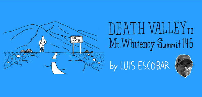
ルイス・エスコバルのカリフォルニア・ランニング通信#4 / デス・バレーからマウント・ホイットニーまでの234km
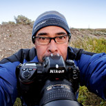
文 ルイス・エスコバル 写真 クリス・クレメンス 訳 大島竜也/三田正明
4回目となる写真家ルイス・エスコバルのカリフォルニア・ランニング通信。今回はデスバレー内のバッドウォーター(海抜−86 m) をスタートし、合衆国本土最高峰マウント・ホイットニー山頂(4,418m)をゴールとする、距離234 km、累積標高5,700m、最高気温50度強という過酷なルートをセルフエイドで走破するというイベントを紹介してくれています。灼熱の荒野を行く、極限の長距離ランニングの様子を写真と一緒にお楽しみください。
■デス・バレーからマウント・ホイットニーまでの234km/Death Valley to Mount Whitney Summit 146
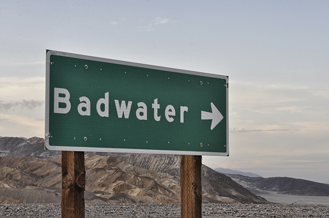
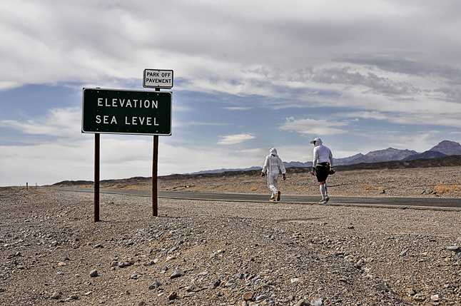
海水が干上がった海の底がどんな様子か想像してみてほしい。カリフォルニア州デス・バレーの東端、ハイウェイ190線上に位置するバッドウォーター・ベイジン(盆地)は海抜-86mで、西半球でもっとも低い地点にある(訳者注:この記述はルイスの間違いで、西半球でももっとも海抜の低いのはアルゼンチンのカルボン湖の-105m)。真夏の大気は熱く強烈で、色彩はまぶしく鮮烈だ。水分は乾ききり、石や砂が焦げたような臭いさえする。ここにあるすべてが大げさで、生けるものを圧倒している。ここでは熱を反射する鎧のような外套を着込んだ動植物でなくては生き延びていけないだろう。灼熱の刃の熱風に巻き上げられた砂粒が散弾銃のように皮膚を襲い、水も、木も、もちろん日陰もない。いっさいの安らぎも同情もないし、もちろん救援など望みようもない。
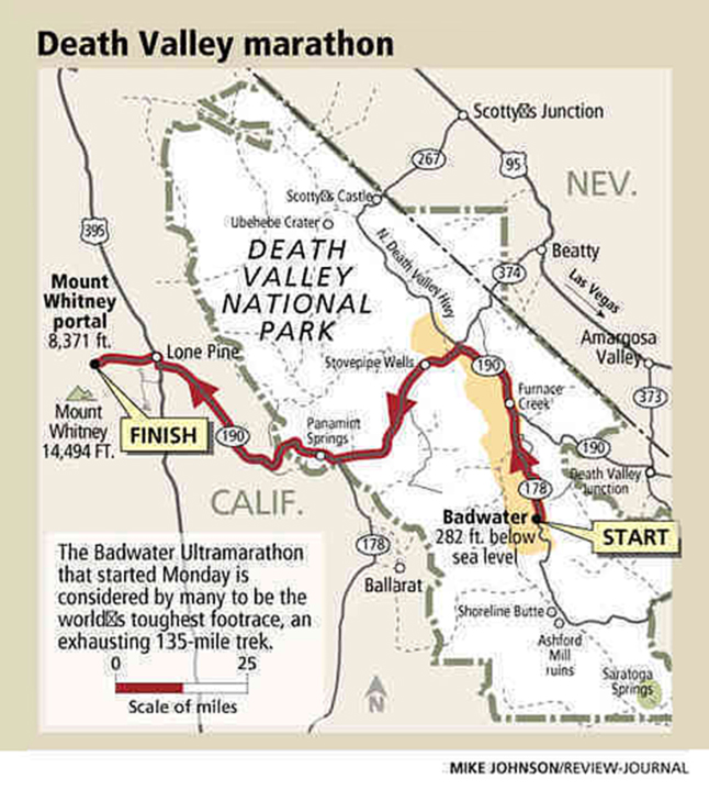
そのバッドウォーター・ベイジンから約234kmの場所に、荘厳なマウント・ホイットニーの頂がある。標高4,418mは合衆国本土の最高峰で、この対照的な二つの地点の間には三つの吹きさらしの砂漠(デス・バレー、パナミント・バレー、オーエンズ・バレー)と三つの高い峠と頂(タウネ・パス1,490m、ファーザー・クロウリー・パス1,460m、マウント・ホイットニー山頂4,350m)がある。234kmの曲がりくねった黒く舗装された灼熱の道路と11kmの険しいシングル・トラックで繫がれており、この二地点の高低差の累積標高は5,700mを超える。
このバッドウォーター・ベイジンからマウント・ホイットニー山頂までの234kmの道のりは、冒険好きな長距離ランナーにとっては危険を冒してでも挑戦したくなる魅力がある。もちろんデス・バレーを夏に走ることはとても危険な行為であり、軽々しく行うべきことではない。コンディションは極限状態でサポートも外部への連絡手段もなく、エスケープ・ルートもない。デス・バレーでランナーは招かれざる客なのだ。砂漠は冷酷で、時に死に至ることもある場所である。立ち入る際は敬意と充分な注意が必要である。
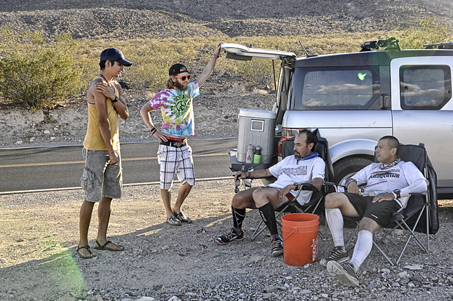
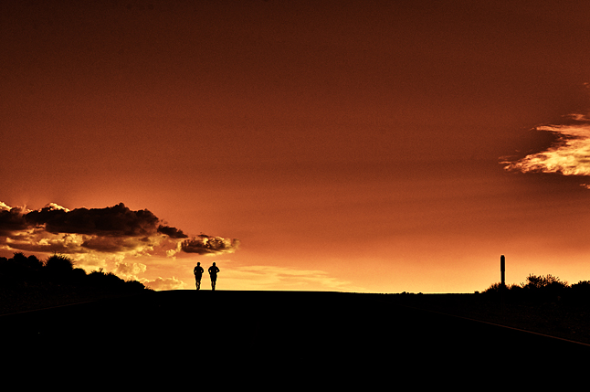
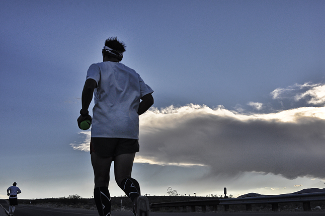
 2014年7月19日土曜日、午前7時。私と友人のマウリシオ・プエルトはバッドウォーター・ベイジンの干上がった塩の平原に立っていた。気温は約43度。ハイウェイ190の先は砂漠の向こうに蜃気楼となって消え、路面はギラギラと照りつける太陽に熱せられ光っている。私たちには3人のサポート・クルーがいて、一台のトラックと一台の乗用車で私たちの砂漠の旅をサポートしてくれる手筈になっていた。
そのランはどの団体からも支援を受けず純粋にセルフ・エイドで実施したイベントで、もちろんレースでもなかった。僕らは西半球で最も低い場所であるバッドウォーター・ベイジンに立ち、米国一高い場所であるマウント・ホイットニーの頂上を自分たちだけで目指すのだ。
最初の目的地はファーネイス・クリーク(小川)にある牧場で、海抜より低い場所を通る26kmの道のりだった。遅い午後の乾燥した大気はむせ返るような暑さだったが、風は穏やかだった。私たちの靴のソールは熱くなった道路のせいで柔らかくなっていたので、熱を避けるため道路の白線を辿って歩いた。目的地のファーネイス・クリークに着く前にあまりの暑さで車が故障したりもしたが、私たちの旅は想定通りに進んでいた。
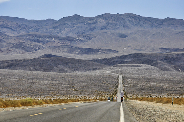
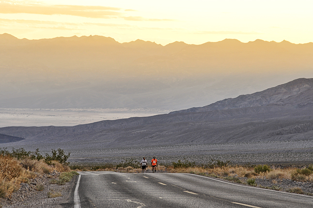
次の目的地は42km先にあるファーネイス・クリーク牧場とストーブパイン・ウェルズの間にある集落で、特に危険なセクションだった。私たちは最も暑い時間帯に砂漠で最も暑い場所を走らなければならないのだ。午後の強い横風が砂利や石を巻きあげて走るのをさらに困難にし、気温は少なくとも摂氏50度を超えていた。さらに迷惑なことに、夏休み中でハイウェイ190は車の通行量が多く、まさかこの猛暑下で人が外を走っていると思わない人々は猛スピードで通り過ぎたかと思うと急停車して、私たちの写真を撮っていた。いずれにしろ道路状況と天候を把握することはとても重要だ。
私たちは夕方早くにストーブパイン・ウェルズに到着し、七面鳥とアボガドをトルティーヤで巻いたラップ・サンド、温かいスープとアイス・キャンディーで軽い夕食を取った。モーテルにあったプールに少し浸かったあと、ギアを取り替えて日没迄のランに向かった。
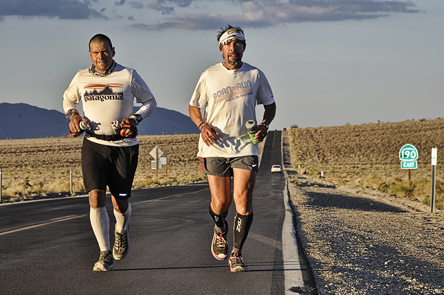
ストーブパイン・ウェルズからタウネ・パス(峠)の頂上までは29kmあり、標高0mから標高1,500kmまで一気に登らなければならない。私たちは走れる場所は走り、きつい場所は歩いて足を進めた。頂上近くで休むことを決め、タープを寝心地の悪い地面に敷いて3時間ほど仮眠して朝4時、ふたたび私たちは頂上を目指した。この辺りのハイウェイ190は急峻で風が強く、道幅も狭かったので走るのに苦労した。24時間を隣り合って走り、マウリシオと私は遂にデスバレーを抜け出して、二日目の朝日があたりを照らす頃にはパナミント・バレーを見下ろしていた。
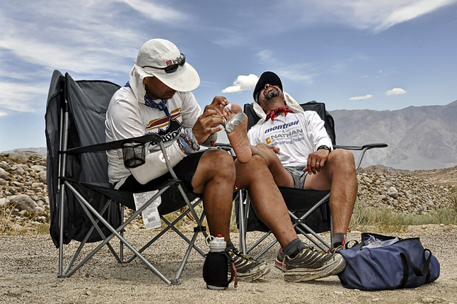
パナミント・バレーまでの18kmは南向きの急な下りで太陽に面していたので眩しく、とても暑かった。7月20日、日曜の昼前に出発から72km地点に位置するパナミント・スプリング・リゾートに辿り着いた。私たちはここで長めの休憩を取り、ガソリンタンクと空腹を満たすことにして、沢山の食事と冷たい飲み物で次の目的地のファーザー・クロウリー・パスの峠越えに備えた。
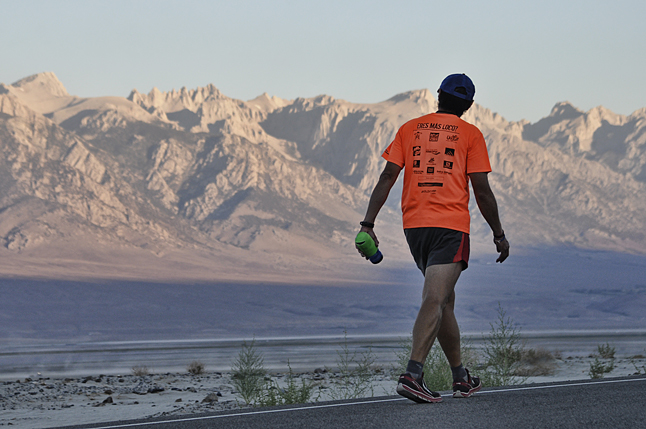
次のセクションでの問題は、ダーウィン近くの砂漠地帯のどこで曲がるかだった。何もない砂漠のなかでオーエンズ・レイクベッド(湖畔)とキーラーの町への方向を示す標識を見つける必要があるのだ。なんとか標識を見つけ、西に向けて走っていくとドラマチックな夕日がシエラ山脈の上にかかり、私たちが目指すオランチャとマウント・ホイットニーが視界にはっきりと見えてきた。日没後も走り続けたが、日が変わった21日月曜午前2時頃に休憩をとることにした。キーラーの町を通り過ぎた辺りで私たちはタープを広げ、星が砂漠の空を照らす下で隣り合っていびきをかいた。
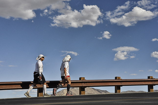
日の出前に目を覚まし、ふたたび走り始めた。オーエンズ・バレーに向かって道を下っていると日が昇り始め、同時に気温も上がっていき、朝7時頃には摂氏43度に、正午には54度にも達した。ローンパインの町を通り過ぎてハイウェイ395を右折し、今回のランで初めて木陰を走ることができた。続いて賑わった小さな町を通り過ぎた頃、ハコヤナギの木陰から出てかんかん照りでのランが再び始まった。マウント・ホイットニーへの入り口にあるアラバマ・ヒルズの道は急な登りで距離も長かったが、ゴール地点のマウント・ホイットニーの頂上までは目と鼻の先の所まで来た。
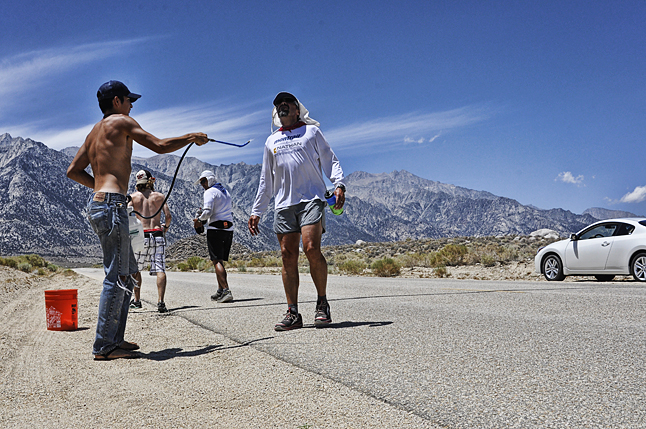
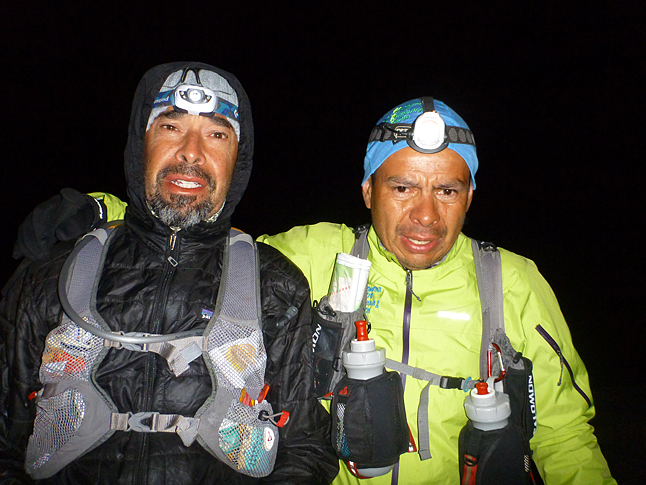
出発点から216km(頂上まで残り18km)にあるホイットニー・ストアに到着したのはその日の午後だった。私たちは標高2,400m地点にいて、空気はとても冷たく、松の木の甘い香りがしていた。ここまで辿り着いた自分達へのご褒美にハンバーガーと冷たいビールで腹ごしらえをし、午後7時に店を出発してトレイルを走り始めた。この2日半の殆どを国道のアスファルトの上で走っていたので、土のトレイルを走るのはとても久しぶりだった。私たちはトレッキング・ポールを手にヘッドランプを装着し、ダウンジャケットとロングパンツに小さなデイパックを背負い、クリスタル・レイクを通り過ぎて頂上へと向かった。
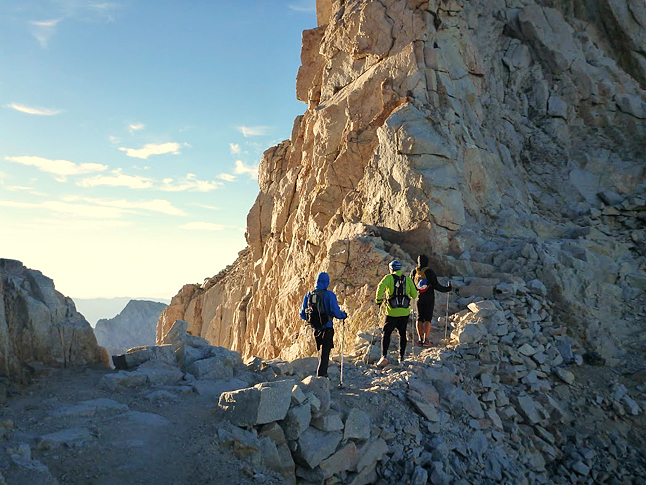
あたりはすぐに暗くなり、気温も冷え込んできたが、運のいいことに空気が澄んでいたせいで道ははっきりと見えた。かの有名な99スイッチバックス(99カ所のつづら折り)を警戒しながらゆっくり進むといつのまにか森林限界を超えていたようで、あたりに木々はなく足下はガレた岩場になっていた。細い尾根道を走っていくとあたりは真っ暗になり、気温もぐっと下がってきた。標高4,200mを超え頂上まで30分ほどの場所まで来ると切り立った尾根道になり、人ひとり通るのがやっとな幅しかなかった。左側にはオーエンズ・バレーとローンパインの町が、右側にはウエスタン・シエラとセコイア国立公園が見わたせた。まさに「もし落ちたら、絶壁におちる雫の如く落下して死ぬ」場所だった。
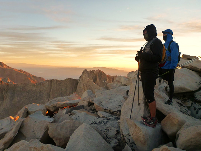
寒さと疲れで足が震えたが、出発から234kmを短い休憩と仮眠を挟んでの66時間で走り、遂にマウント・ホイットニーの頂上に到着した。私たちは最も高い場所に立ち、二人で握手している様子を写真に撮った。シェルターのあるストーン・ハットに戻った頃にはもう24日の午前1時30分になっていた。私たちは朝日を待ち、自分たちの足跡を辿りながら18kmの下山の路についた。
バッドウォーター・ベイジンからマウント・ホイットニー山頂までの234kmは万人に薦められるものではない。とても危険で困難であり、費用もかかる。今回は私にとって4度目の経験だったが、それでもランナーとして自分自身を謙虚に、そして高めてくれるとても有意義な経験になった。砂漠や高峰の峠道にはいまだ隠されたシークレットがまだまだ残されている。そしてそれは、心身の疲労の先に初めて見つけられるものなのだ。学ぶべきなにかがそこにはある。
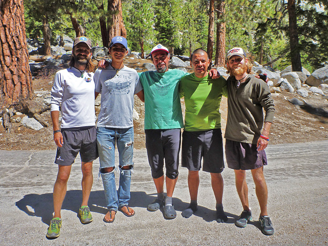
このエッセイをサポートクルーのメンバーに捧げる。
クレメンス兄弟、クリスとテイラー、そしてグレゴリオ・ポンセに。この極限の長距離ランニングはチーム・アクティビティであり、若き彼らの助けなしになし得ることはできなかった。彼らは自分たちのことは後回しに常にランナーのことを気にかけてくれた。私は一生感謝してもしきれない。そして旅の様子を写真に収めてくれたクリス・クレメンスにも大きな感謝を。
最後にランニングパートナーのマウリシオ。君の我慢と寛大な心に本当に感謝する。そして、何より私の妻であるビバリーに。変わらぬ信頼とサポートをいつもありがとう。
■Death Valley to Mount Whitney Summit 146 By Luis Escobar
Text : Luis Escobar
Photo : Chris Clemens
Imagine the floor of a dry sea or the bottom of an ocean with no water.
The Badwater Basin is located on Highway 190 in the far eastern corner of Death Valley California. At two hundred and eighty two feet below sea level, it is the lowest point in the Western Hemisphere. In Death Valley the mid summer air is heavy with heat and the taste of burnt rock and sand. It is a place of intense saturation, everything here is exaggerated, it all seems bigger than life. The colors are more vivid, deep and bright. The wind is strong and it caries pellets of hot sand and searing blades of heat. The plants and animals here wear thick coats of heat reflecting armor. There is no water, there are no trees, there is no shade. The desert offers no comfort, no sympathy and absolutely no relief.
Coincidentally, just 146 miles away from the Badwater Basin stands the rocky and majestic summit of Mt. Whitney. At 14,505 feet above sea level, the peak of Mt. Whitney is the highest spot in the contiguous United States. Between the two points, there are three windswept desert valleys (Death Valley, the Panamint Valley and the Owens Valley) In addition, there are three tall mountain passes (Towne Pass 4956′ and Fr. Crowley Pass 4879′ and Mt. Whitney summit 14,505′) There is 135 miles of undulating, heat radiating, black pavement and 11 miles of arduous, rocky, single track trail. The total cumulative elevation gain between the two points exceeds 19,000 feet.
The Badwater to Mt. Whitney 146 route is a tempting problem for an adventurous long distance runner. Summer running in Death Valley California is a serious and dangerous undertaking. It should not to be taken lightly. The conditions here are extreme, there is no support, no communication and no real exit. When you run in Death Valley you are an uninvited guest. The desert is indifferent. There are deadly consequences. Enter with respect and caution.
At 7:00am on Saturday, July 19, 2014, my good friend, Mauricio Puerto and I stood on the salt flat floor of the Badwater Basin. It was 110 degrees. Before us we could see Highway 190 disappear into the shimmering desert. The road was glossy with heat and glaring sun light. We had a support crew of three friends, one truck and one car that would follow us on our journey through the desert.
Our run would be pure, self aided, not affiliated with any organized event. This was not a race. We were standing at the bottom of the earth, we were running to the top and we were on our own.
Our first goal was the 16 mile section to the ranch at Furnace Creek. This entire distance is well below sea level. The late morning air was thick, calm and dry. The soles of our shoes were softened by the hot street. We would run on the white line for relief from the black pavement.After some heat related car trouble, we arrived at Furnace Creek (mile 16). We were hot and dry but in full control.
Our next goal was the long 26 mile section between the Furnace Creek Ranch and the tiny community of Stovepipe Wells. This is a particularly dangerous section of road. We would be running in the hottest part of the desert, during the hottest time of the day. The strong afternoon side wind rushes across the hot gravel and rock which creates a powerful confection effect. Here the ambient temperature was well over 125 degrees. In addition, the midsummer tourist traffic on Highway 190 is high. Drivers and tour busses are not expecting to see people running. They are either driving very fast or stopping to take pictures of us. Either way, it’s an awkward encounter and it is very important to pay close attention to the road conditions weather and traffic.
We arrived at Stovepipe Wells (mile 43) in the early evening. We had a light dinner of turkey and avocado wraps, warm chicken soup and Popsicles. After a quick dip in the motel pool, we changed into our night time running gear and headed out towards the sunset.
Stovepipe Wells to Towne Pass Summit is a 18 mile assent from elevation zero below to nearly 5000 feet above. We ran what we could and walked what we could not. Near the summit we decided to rest. We spread tarps on the ground and slept uncomfortably for nearly three hours.
By 4:00AM on day two we were back on our feet and moving toward the summit at Towne Pass(mile 61). Here Highway 190 is steep, winding and narrow. Side by side for nearly 24 hours, Mauricio and I had now run through Death Valley and when dawn broke on the second morning, we were looking across the Panamint Valley.
The 11 mile descent into the Panamint Valley is steep, south facing, exposed and white hot. We scrambled into the Panamint Springs Resort (mile 72) in the late morning on Sunday, July 20. There we refueled our support vehicles and ourselves. After a long break, a big meal and plenty of cold drinks we started up towards the overlook at Fr. Crowley Summit.
The next point of significance is the high desert turn near Darwin. There is nothing at the Darwin turn but a sign post pointing the way to the dry Owens Lakebed and the tiny town of Keeler several dusty miles below.We were traveling west as evening fell on day two, running into a dramatic sunset and directly towards the High Sierra. Langley, Olancha and Whitney are now clearly in our view.It was about 2:00Am on Monday, July 21 when we decided to take another break. Somewhere outside of Keeler, we spread our tarps on the ground and laid there side by side, snoring into a star lit desert sky.
We were up and running again prior to sunrise. As we descended into the Owens Valley, the sun was rising and so was the temperature. It was 110 degrees by 7:00am close to 130 by noon. Outside of the town of Lone Pine, we turned right onto Highway 395. For the first time in almost three days we were now running in the shade of trees. Soon we pass through the busy little town and away from the shelter of the Cottonwoods. We are now moving through the Alabama Hills on Whitney Portal Road. It is very hot, the road is steep and long but the summit of Whitney seems close enough to touch.
It is early afternoon when we reach the Whitney Store (mile 135) We are now at 8,000 feet. The mountain air is cool and sweet with pine. We treat ourselves to a burger and a cold beer. It’s about 7:00pm when we depart the store and step on a dirt trail for the first time in two and a half days. Sporting trekking poles, headlamps, down jackets, long pants and a small day pack we work our way past Crystal Lake towards the summit.
Night comes fast, hard and cold. We are in luck, although it is very cold the trail is clean and well defined. We are moving slowly and deliberately up the famous 99 switchbacks. We are now well above the timber line, the trail is field of scree, scrabble and loose rock. It is very dark and very cold as we traverse the thin spines and ridges. At around 14,000 feet above the sea and maybe thirty minutes from the Whitney Summit the trail clings to a vertical cliff face and then traverses a razor thin ridge. On my left is the Owens Valley and the town of Lone Pine. To my right is the Western Sierra and Sequoia National Park. This is a “you fall you die precipitous drop”.
It is on cold and unstable legs that we reach the rocky summit of Mt. Whitney (mile 146) it had taken us just over 66 hours of nearly continuous motion to get to this point. Standing there on the highest spot in the lower fourth-eight, we take a few photos with our shaking hands. It is 1:30am on Tuesday, July 24 when we retreat to the Stone Hut for shelter. There we wait for sunrise and then retrace our steps 11 miles back down the mountain.
The Badwater to Mount Whitney Summit 146 may not be for everyone. It is very difficult, it is dangerous and expensive. This was my 4th time to make the trek and for me it is a humbling and enriching experience.There are secrets hidden in those deserts and high mountain passes. There are secrets hidden beyond physical and mental exhaustion. There are lessons to be learned out there.
This essay is dedicated to our crew, the Clemens brothers, Chris and Tyler and the young Gregorio Ponce. Extreme long distance running is a team activity and without these boys our journey would not have happened. They were selfless and attentive. I am forever grateful.
Special thanks to Chris Clemens who documented the run with his camera.
Thanks to my friend and running partner, Mauricio Puerto. I appreciate your patience and tolerance. Most of all thank you to my wife Beverly for her continued trust and support.
TAGS:


 ULギアを自作するための生地、プラパーツ、ジッパー…
  Tenkara USA | RHODO (ロード)
  Tenkara USA | YAMA (ヤマ)
  Tenkara USA | Rod Cases (…
  Tenkara USA | tenkara kit…
  Tenkara USA | Forceps & …
  Tenkara USA | The Keeper …
  Tenkara USA | 12 Tenkara …
  Tenkara USA | Tenkara Lev…


