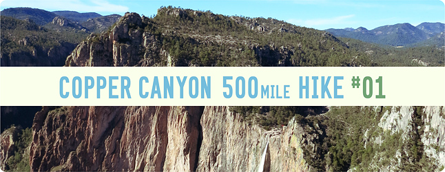
Copper Canyon 500mile Hike #1 / コッパーキャニオン500マイルハイク#1
写真/文:Justin Lichter 訳:大島竜也/三田正明
編集部がトラウマにコンタクトをとったのが、2013年8月。ソルトレイクにてEVERNEW社によって開催されたウルトラライトギアメーカーの重鎮、著名なハイカー、ライターが集うMINIMALIST PARTYでのこと。勝手な憧れと妄想から緊張気味な僕らをよそに、あれだけの偉業をなしとげたという著名な彼は、驚くほど気さくで独特の雰囲気を醸し出す素晴らしいハイカーだった。そんな彼と、本TRIP REPORTの企画で最初のミーティングをしたのは彼が30日程度のハイキングトリップから帰ってきたばかりことだった。開口一番、その旅先を聞いて衝撃がはしった。世界中のランニングシーンに新しい風を吹き込んだ書籍「Born to Run」の舞台として知られるメキシコはコッパーキャニオンが旅先だったというのだ。ランニングフィールドのイメージが先立つコッパーキャニオンをトラウマがハイキングトリップしたらどんな旅になるのか…。こうして、トラウマのTRIP REPORTの第一弾が決まった。全5回、500マイルのハイキングトリップ! ご堪能あれ。
■カムとの出会い
僕がカム・ホーナンに初めて会ったのは、9月最終週の晴れた土曜日だった。この2~3年の間、彼とはEメールなどで連絡を取り合ってはいたものの、実際に会うのはその時が初めてだった。
カムが僕に連絡をくれたのは7月のことで、そこから何度かメールのやり取りするうちに、僕は秋にメキシコのコッパーキャニオンをハイクする計画があることを彼に伝えた。 するとカムから返信があり、実は彼も同じ計画をしていて、しかも過去に何度かコッパーキャニオンに行ったこともあるという。
お互い経験を積んだロングディスタンス・ハイカーとして、僕たちのその旅での目標や意図はほぼ同じだった。かつこれまでの経験から、コッパーキャニオンのハイキングは厳しい旅が予想されるということもわかっていた。そしてお互いの人生観がよく似ているということも。さらにコッパーキャニオンをソロで横断することの過酷さを考慮すると、論理的に導かれる次のステップはふたりでチームを組むことだった。
On a sunny Saturday in the last week of September, I met Cam Honan in person for the first time. Over the past couple of years we had been in off and on e-mail communication, but we had never met in person. Cam e-mailed me with a question in July. After a few exchanges it came up that I was thinking about heading to the Copper Canyon in Mexico for a hike in the Fall. He replied by saying that he was also considering a trip to the region, which he had been to a few times prior. As two experienced long distance hikers, we realized that our goals and intentions for the trip were similar, as well as our outlook on situations and circumstances we could encounter, and life in general. The next logical step was to team up since the dangers of the region far outweighed the practicality of completing the traverse solo.
カムと初めて対面したのはALDHA-West (長距離ハイキング協会西部地区) が開催する年に一度のハイカー・ギャザリングの会場だった。その集会は僕らロングディスタンス・ハイカーの間で「噂のあいつはどんなやつだ?」を知ることができる場としてよく知られており、その時は僕も含めてトリプルクラウンを制覇した人間が20人も参加していた。
20人それぞれがすでに(Triple Crownの長さ)7,700マイル以上(12,320km=沖縄~北海道間を約2.5往復分)をハイクした経験があり、さらにはその2倍~3倍、いや7倍以上もハイクした人間もいた! もしここにいる全員がハイクした距離を合計したら、どこかのジャンクヤードにある廃車のマイル数を合計した距離を超えるかもしれない。しかも、みんなまだ歩き続けている!
At an annual long distance hikers gathering for the ALDHA-West long distance hiking club, we met in person for the first time. The Gathering, as it is know to many long distance hikers, is a venerable “who’s who” of long distance hiking. At this Gathering there were over 20 Triple Crowners (people who have hiked the three major long trails in the United States, the Appalachian Trail, Pacific Crest Trail, and Continental Divide Trail). Each one of these people has hiked over 7,700 miles. Some people in attendance had hiked 2, 3, 4, and even 7 times that amount! If we added up the total mileage at the festival it would have easily exceeded the cumulative mileage of all of the cars in some junkyards………but we are all still walking!
■ルート決定
ALDHA-West が開かれたのは、あの急勾配で、ドラマチックで、かつ危険を孕んだコッパーキャニオンに向かうわずか4週間前のことだった。僕らは顔を合わせるとすぐに地図を広げたが、地図はハイカーが集まる場所ではまるで磁石のように働く。僕らのまわりにはすぐに黒山の人だかりができた。
僕たちはALDHA-Westが行われた週末の間ずっと旅の計画を練り、その後はカムが僕の家に来て話合いを続けた。遂に基本のルート、ルートと思われる場所、および何かあった時の代替ルートや避難場所、そして物資補給の方法が決まり、カムは飛行機で家へと帰っていった。
僕らはその後もメールやスカイプで計画を詰めていったが、 結局次に彼と会うのはメキシコ・チワワ州のコッパーキャ二オン入り口近くの町のバス停という事になった。
When I met Cam for the first time it was only four weeks before we were scheduled to head out into the steep, dramatic, and dangerous landscape of the Copper Canyon region. We immediately pulled out maps at the hiker festival. Maps at a gathering of hikers act like a magnet. We were immediately surrounded by a group of curious people. We worked all weekend at the get-together and then went back to my house for the next few days. We finalized the route, or what we intended to be the route, alternates in case issues rose, areas to stay away from, and potential resupply options. He then flew back home and we corresponded once again by e-mail and Skype calls. The next time I would see Cam we would be in Chihuahua, Mexico, taking the bus to the start of the hike.
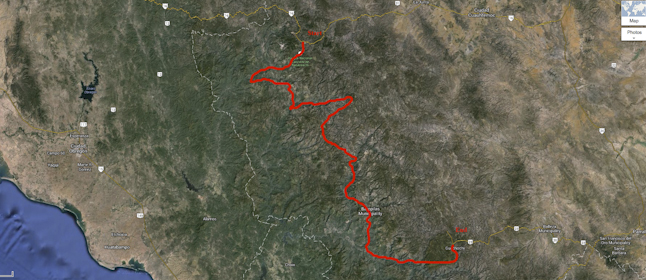
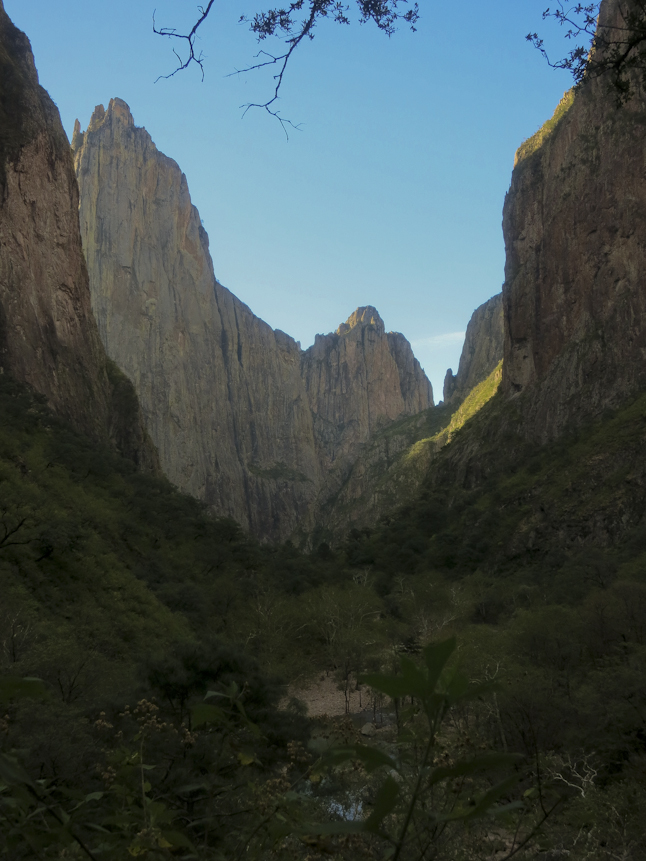
ルート決定のプロセスの中で僕らは写真や地図など情報となり得るありとあらゆるものに目を通し、今回のハイキングのルートをコッパーキャニオン北側にあるバサセアチ渓谷から歩き初め、南側に位置する6つの主要な峡谷を束ねるグアチョーチの頂上までと設定した。
これら主要な峡谷は約6,000フィート(=約1,830m)もの深さあり、急な壁面や断崖絶壁、激しい勾配を有しており、実際のところ、その深さはアメリカのグランドキャニオンを超えている。 僕らのルートをヒモで測ったところ、推測で約350~500マイル(560~800km=560kmは東京~青森間程度。800kmは東京~北海道間程度)プラス2~3割程度の距離があることがわかった。
During the planning stages we looked over maps, photos, and any other information we could find. The goal of the trip was to hike from the north of the Copper Canyon region at Basaseachi Falls to the south at the Cumbres de Guachochi (Summit of Guachochi) connecting all six of the major canyons in the area. These major canyons are over 6000 feet deep. They are gorged out with steep walls, cliffs, and drastic elevation changes. In fact, they are deeper than the Grand Canyon in the United States. After measuring the route with string we surmised that the total length of the route would be somewhere between 350-500 miles plus 20-30% because of the lack of details and inefficiency of measuring with string.
僕たちは目的地に危険が潜んでいることを知っていた。コッパーキャニオンは麻薬栽培とその取引で悪名高い場所で、実際アメリカ政府はこの地域に対して危険地域として旅行しないよう警告を出したばかりだ。
だがハイクのほとんどを人里離れた場所を歩くので、僕たちはあまり心配していなかった。僕たちが最も気がかりだったのが、人里離れた場所にある非合法農地の周囲に設けられた人を寄せ付けない仕掛けだった。この仕掛けに引っかかって転んでしまえばその隙に金目当てで殺される危険性だってあるし、死体を山に捨ててしまえば誰も気づきやしない。
その他にも岩から岩へと飛び移る際に足をくじいてしまうことや、永遠に続くようにゆるくなだらかな平野を渡る際に食料を食べ尽くしてしまうこと、前に進むことを不可能にするかもしれない滝や浅瀬も気がかりだった。
今回の旅において予測不可能なことは数限りなくあり、また地図の精度もそこから地形を探るにはほど遠い酷いものだった。とにかく僕たちにできることは持てる力を最大限発揮して、行く先々で適応していく他ないのだ。
We knew some of the dangers that exist for the region. Copper Canyon is notorious for drug cultivation and drug trafficking. In fact the United States State Department currently has travel warnings and advisories for the region. They recommend people not travel to the area. Being in the middle of nowhere most of the time on the hike, we were less worried. Our biggest concerns were stumbling across clandestine agricultural fields in remote areas. People could kill us and dump our bodies and nobody would ever know. Some of our other worries included twisting an ankle while rock hopping and scrambling over tediously slow terrain, running out of food because of said tediously slow terrain, or impossible fords or waterfalls that would make our passage down or up the canyon impossible. The unknowns were countless and the maps were horrible at depicting how the landscape actually looked and how steep it really was. We would just have to fly by the seat of our pants and be able to adapt on the go.
■コッパーキャニオンへの道
11月の2週目、 カムと僕は埃っぽく薄汚いチワワの街(チワワ=スペイン語で平地という意味)で落ち合った。ふたりで朝食をとり、バスに乗り、ベースキャンプ先となるクリールという町に5時間かけて向かった。
ふたりとも大きなダッフルバッグをふたつ持っていたが、ひとつはメキシコでは手に入らないエナジーバーやインスタント食品などハイカー御用達の食糧で埋め尽くされ、もう一つには予備のハイキングギアが入っていた。 食糧の入ったバッグは45kgほどあったが、おそらく帰る頃には15kgほどになっているだろう。 なぜならこれから始まる約1ヶ月にわたるハイキングで食べてしまうから!
僕らはクリールでコッパーキャニオンについて知っている人を探したが、ただでさえ道端から100m入ると誰もいない様な場所でそんな人を探すのは困難だった。やっとホテル辿り着き、少しは信頼できそうなロビー近くのクローゼットに荷物を預けた。
僕らの試算では次に食糧の補給ができるのは機会は10日後だったが、不確定要素が多く、かつ予測不能な出来事が待っているであろうことを考慮すると、その倍程度の日数がかかる可能性もあった。とにかく、僕らは最初の補給ポイントまでの食糧と道具を配分し、荷物をまとめた。
明日の早朝には、ハイキング出発点へと向かうバスがホテルにやってくる。僕らは少しはましな夕食をとり眠りについたが、明日からのハイキングの事を思うと次々と心配事が頭を巡り、なかなか寝付けなかった。
It was the second week of November, Cam and I met in the dusty, dirty city of Chihuahua, Mexico. Chihuahua is in the flatlands. We grabbed some breakfast and boarded the coach bus for the 5-hour bus ride to Creel. Creel would be our base camp. We both flew to Chihuahua with two large duffel bags. One full of hiker friendly food that we knew we wouldn’t be able to purchase in Mexico, like bars and quick cook meals, and the other with spare equipment that we wouldn’t be able to find. I had nearly 100 pounds of baggage and I would only return home with about a third of it because I would eat over 60 pounds of it within the next month while hiking! We stayed the night in Creel trying to find any locals who had knowledge of the regions we were about to traverse. It was difficult even finding any locals who had strayed over 100 meters from the end of the road. Finally we located a hotel in Creel that would allow us to store our duffel bags in a reasonably safe closet near the lobby. Our calculations showed that the first segment until we could resupply again would be ten days, but with all of the questions marks and unknowns the reality was that it could take twice as long. We then divvied up our food and gear for the first stretch and packed our backpack. The bus passing by where we were to start the hike left early the next morning. We ate a least good meal for dinner and then slept restlessly anticipating the hike and repeating in our mind what we had packed so we wouldn’t miss anything.
■DAY1 /新しい章の始まり
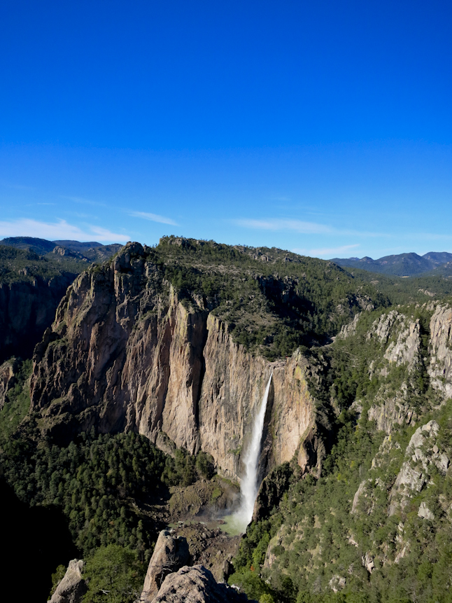
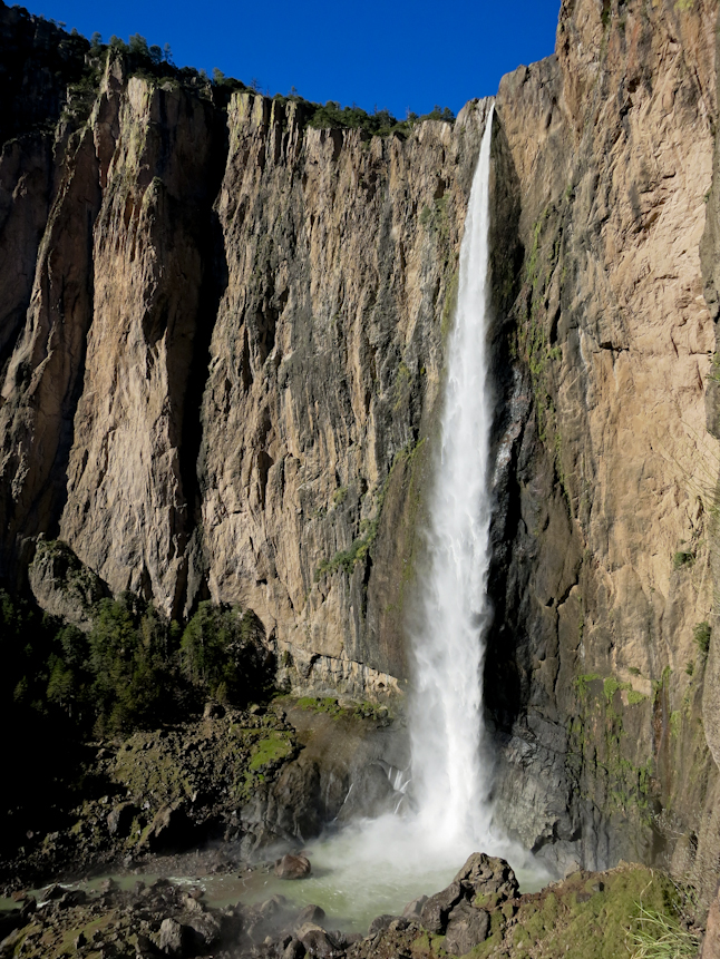
風が強いゆるやかな道を3~4時間バスに揺られた後、僕らは興奮気味にバサセアチのバス停に降り立った。 このメキシコで二番目の大きさを誇るバサセアチ滝がある国立公園の入り口が、僕らのハイキングの正式なスタート地点だった。
一時間ほど舗装路を歩くと道はハイキング・トレイルになり、ほどなく僕らは滝の頂上に到着した。 滝の水は300m以上も下にある砂岩の塊に落ちており、周囲の景色も目を見張るほどだった。 その僕らがこの旅で初めて目にした険しくもドラマチックな峡谷の景色で、僕はすでに良い気分になってしまっていたが、「これから様々な困難が待ち受けているんだぞ」と自分に言い聞かせた。
それにしてもその景色は素晴らしく、それはこの旅全体のトーンを決定着けるものとなった。力強く美しい滝、そして少々の未知。 果たしてこの滝の下まではどうやって辿り着くのだろう? この道はどこにつながっているのだろう?
After another 3-4 hour bus ride on windy slow roads, we exited the bus at the small town of Basaseachi. We officially started the hike here on the entrance road to the National Park containing Basaseachi Falls, the second largest waterfall in Mexico. After about an hour of walking on a paved road, which turned to a hiking trail, we arrived at the top of the falls. Water was pouring over 1000 feet down an unbroken sandstone slab. The scenery around the falls was equally dramatic and stunning. It was my first glimpse of the canyons we had agreed to traverse and put the steepness and dramatic landscape fully into perspective. This was an audacious task. We would have many twists and turns and have to be ready for anything.The location of the start of the hike was amazing. It set the tone for the entire trip. A powerful and beautiful waterfall, with a bit of unknown. How do we get to the bottom? Which trail leads where?
ハイキング最初の1時間といえば大抵容易で、思慮深くなる必要のない時間だけれど、それがこんなに冒険だったことがあっただろうか?滝の上の川にかかる橋は雨期の影響で朽ち果てており、壊れた道標は明後日の方向を指していた。川には岩づたいに横断できそうな箇所もあったが今にも川に飲み込まれそうで、岩の上も滑りそうだった。川に飲み込まれ滝に落ちることは死を意味する。仕方なく僕らは川沿いに滝から上流の方角へと向かうことにしたが、このことによりそこから数日間カンダメナ峡谷をハイキングすることが決定づけられた。
そこはハイカー用語で言うならば“Scrambly Fun”な渓谷で、その意味は「常に危険に注意を払うべきだが、退屈なゆっくりとよじ登る道が続く」ということである。僕らが景色の見えるポイントや、峡谷の底へと続く道を探していると、太陽は深い峡谷の壁に隠れてしまい、陽が続くのは残り1時間程になっていた。
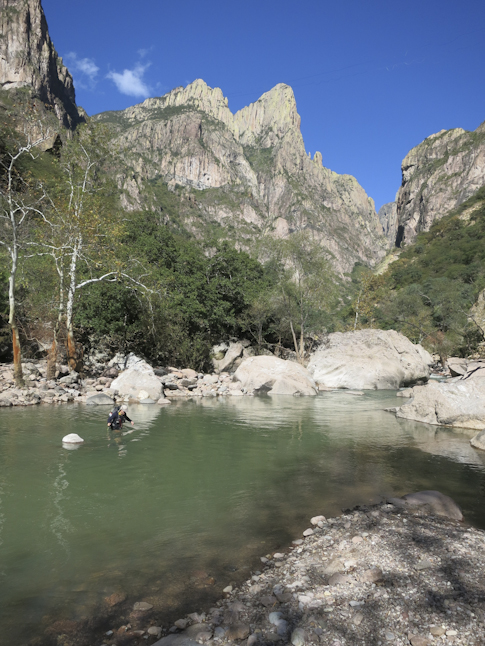
僕らは峡谷を引き続き下り、小さな清流をいくつか過ぎ、川沿いに今夜の寝床に相応しい場所を見つけた。僕らはそこでキャンプをし、翌日は初めて一日中ハイキングできることや次に到着する川沿いに何が待ち受けているか、ウキウキしながら眠りについた。
川の曲がった先にはいつも新しい発見があり、それはまるで新しい章の始まりのようだった。
The bridge over the creek at the top of the falls had washed out during the rainy season prior to our arrival. Sections were dangling and leading to nowhere. What could have been easy and thoughtless turned into an adventure within the first hour of the hike. There is a natural bridge over the river just before it plunges over the precipice, but the bridge was narrow and the rock looked slick. A fall would undoubtedly mean death.
We were forced to ford the river immediately upstream from the waterfall. This set the stage for the next couple of days down Candamena Canyon. It was scrambly fun, which translates in hiker lingo to “you better pay attention at all times and often tediously slow”.
By the time we scouted out a few viewpoints and the way to descend into the bottom of the canyon, the sun was behind the steep walls and we only had another hour of daylight. We continued down canyon passing a couple more small waterfalls pouring into the main canyon and found a campsite along the river bottom. We slept well eager for the start of our first full day of hiking and to see what was around the next bend in the river. With each twist and turn there was something new. It was like opening a new chapter.

TAGS:


 ULギアを自作するための生地、プラパーツ、ジッパー…
  Tenkara USA | RHODO (ロード)
  Tenkara USA | YAMA (ヤマ)
  Tenkara USA | Rod Cases (…
  Tenkara USA | tenkara kit…
  Tenkara USA | Forceps & …
  Tenkara USA | The Keeper …
  Tenkara USA | 12 Tenkara …
  Tenkara USA | Tenkara Lev…